Photographers know: Composition can make all the difference. And while pretty much all photos of Earth from space are breathtaking, various space travelers and satellites have, over the years, captured some pretty creative angles.
To celebrate Earth Day, we dug through the Commons for some photos of Earth from far away that you may not have seen before. All of the descriptions come straight from the source — NASA. And yes, there’s even one with a finger in the shot, which goes to show that even astronauts sometimes have a hard time with the technical elements.
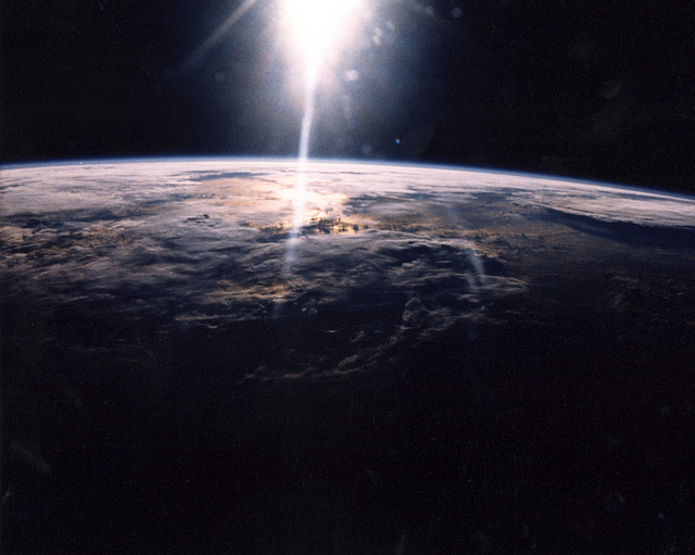
Sunlight over Earth as seen by STS-29 crew
“A 35mm camera was used to photograph sunlight over a cloud- covered Earth surface by STS-29 crewmembers onboard Discovery, Orbiter Vehicle (OV) 103. This photographic frame was among NASA’s STS-29 photo release on Monday, March 20,1989. Discovery was launched on March 13,1989, with the crew of Michael L. Coats (Commander), John E. Blaha (Pilot), James P. Bagian (Mission Specialist), James F. Buchli (Mission Specialist), and Robert C. Springer (Mission Specialist).”
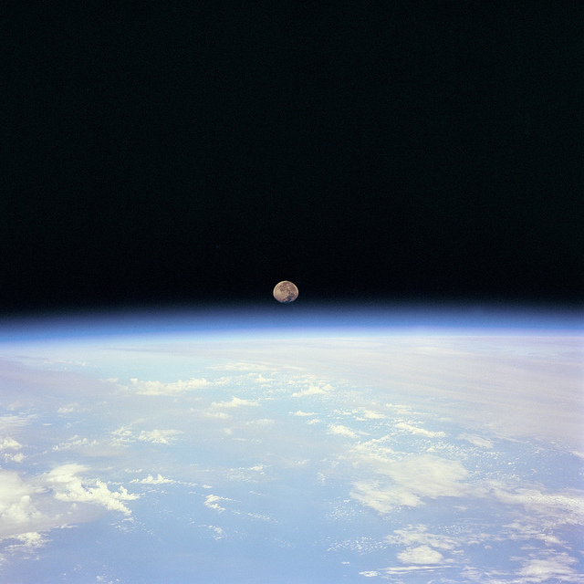
“Moon set over the Earth limb taken from Space Shuttle Discovery during STS-70 mission.”
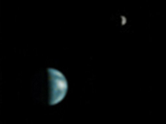
Earth and Moon As Viewed From Mars
“(May 8, 2003) This is the first image of Earth ever taken from another planet that actually shows our home as a planetary disk. Because Earth and the Moon are closer to the Sun than Mars, they exhibit phases, just as the Moon, Venus, and Mercury do when viewed from Earth. As seen from Mars by the NASA Mars Global Surveyor on May 8, 2003, at 13:00 GMT (6:00 a.m. PDT), Earth and the Moon appeared in the evening sky. This Earth/Moon image has been specially processed to allow both Earth (with an apparent magnitude of -2.5) and the much darker Moon (with an apparent magnitude of 0.9) to be visible together. The bright area at the top of the image of Earth is cloud cover over central and eastern North America.
Below that, a darker area includes Central America and the Gulf of Mexico. The bright feature near the center right of the crescent Earth consists of clouds over northern South America. The image also shows the Earth-facing hemisphere of the Moon, since the Moon was on the far side of Earth as viewed from Mars. The slightly lighter tone of the lower portion of the image of the Moon results from the large and conspicuous ray system associated with the crater Tycho.”
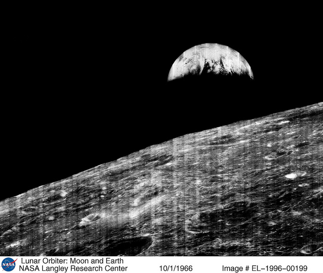
The World’s First View of Earth
“(October 1, 1966) The world’s first view of the Earth taken by a spacecraft from the vicinity of the Moon. The photo was transmitted to Earth by the United States Lunar Orbiter I and recieved at the NASA tracking station at Robledo de Chavela near Madrid, Spain. This crescent of the Earth was photographed when the spacecraft was on its 16th orbit and just about to pass behind the Moon. This is the view the astronauts had when they came around the backside of the Moon and face the Earth.
The Earth is shown with the U.S. east coast in the upper left, southern Europe toward the dark or night side of the Earth, and Antartica at the bottom of the Earth crescent. The surface of the Moon is shown on the right side of the photograph.”
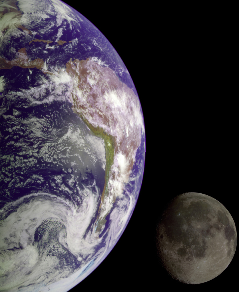 “During its flight, the Galileo spacecraft returned images of the Earth and Moon. Separate images of the Earth and Moon were combined to generate this view. The Galileo spacecraft took the images in 1992 on its way to explore the Jupiter system in 1995-97. The image shows a partial view of the Earth centered on the Pacific Ocean about latitude 20 degrees south.
The west coast of South America can be observed as well as the Caribbean; swirling white cloud patterns indicate storms in the southeast Pacific. The distinct bright ray crater at the bottom of the Moon is the Tycho impact basin. The lunar dark areas are lava rock filled impact basins.
This picture contains same scale and relative color/albedo images of the Earth and Moon. False colors via use of the 1-micron filter as red, 727-nm filter as green, and violet filter as blue. The Galileo project is managed for NASA’s Office of Space Science by the Jet Propulsion Laboratory.”

Clouds and Sunglint over Indian Ocean
“Clouds and sunglint as seen during the STS-96 mission from the Space Shuttle Discovery.”

First Picture of Earth and the Moon in a Single Frame
“(September 18, 1977) This picture of the Earth and Moon in a single frame, the first of its kind ever taken by a spacecraft, was taken by NASA’s Voyager 1 when it was 7.25 million miles (11.66 million kilometers) from Earth. The moon is at the top of the picture and beyond the Earth as viewed by Voyager. In the picture are eastern Asia, the western Pacific Ocean and part of the Arctic. Voyager 1 was directly above Mt. Everest (on the night side of the planet at 25 degrees north latitude) when the picture was taken.
The photo was made from three images taken through color filters, then processed by the Image Processing Lab at Jet Propulsion Laboratory (JPL). Because the Earth is many times brighter than the Moon, the Moon was artificially brightened by a factor of three relative to the Earth by computer enhancement so that both bodies would show clearly in the prints.
Voyager 1 was launched September 5, 1977 and Voyager 2 on August 20, 1977. JPL is responsible for the Voyager mission.”
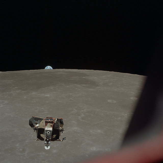
Apollo 11 Lunar Module ascent stage photographed from Command Module
“(July 21, 1969) The Apollo 11 Lunar Module ascent stage, with Astronauts Neil A. Armstrong and Edwin E. Aldrin Jr. aboard, is photographed from the Command and Service Modules in lunar orbit. This view is looking west with the earth rising above the lunar horizon. Astronaut Michael Collins, command module pilot, remained with the Command/Service Module in lunar orbit while Armstrong and Aldrin explored the Moon. The Lunar Module is approaching from below. The mare area in the background is Smyth’s Sea. At right center is International Astronomical Union crater no. 189.”
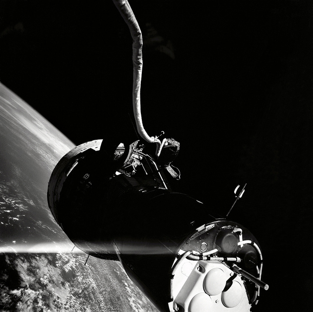
“An unusual view of the Gemini 9 spacecraft taken by Eugene Cernan during his Extravehicular Activity (EVA). His umbilical and spacecraft are visible though he is not.”